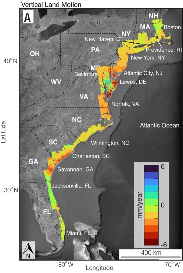
Based on satellite images, geologists determined that major cities on the U.S. Atlantic coast are sinking, in some areas by 2 to 5 millimeters (0.08 to 0.2 inches) per year.
This sinking of land, known as land subsidence, is occurring at a faster rate than estimated just a year ago.
In a new paper published in Proceedings of the National Academy of Sciences, The researchers say their analysis has far-reaching implications for resilience planning for communities and infrastructure, particularly roads, airport runways, building foundations, railways and pipelines.
These coastal areas, which include populated areas such as New York City, Baltimore, Virginia Beach, and Norfolk, are also vulnerable to weather and storm problems. The problem of land subsidence compounds the problems caused by increasingly severe storms due to climate change.
“Continued unmitigated land subsidence on the U.S. East Coast should raise concerns,” said lead author Leonard, a graduate student working with Associate Professor Manuchel Shirzaei at Virginia Tech’s Institute for Earth Observation and Innovation.・Mr. Owenhen stated. Virginia Tech said in a press release.
“This is especially true in areas with high population and real estate densities and strong historical satisfaction with infrastructure development.”
A research team from Virginia Tech and the U.S. Geological Survey used satellite imagery and radar data to create a digital terrain map that pinpoints where subsidence poses the greatest risk to critical infrastructure.
Using multi-year data, they show that large areas of the East Coast are sinking by at least 2 mm (0.08 inches) per year, and some areas along the mid-Atlantic coast (up to 3,700 square kilometers, or more than 1,400 square kilometers) ing. square mile – sinks more than 5 mm (0.2 inches) per year.
To further complicate matters, the current rate of global sea level rise is estimated to be approximately 4 mm per year.
“We measured a subsidence rate of 2mm per year affecting more than 2 million people and 800,000 properties on the east coast,” Sirzaei said.
“We know to some extent that land is sinking. Through this study, we emphasize that land sinking is not an invisible threat. It may be gradual, but the impact is real.”
In their paper, “Slowly but surely: Communities and infrastructure are subject to subsidence on the U.S. East Coast.” The research team wrote that they assessed the risk of land subsidence to populations, assets, and infrastructure systems/facilities along the U.S. East Coast.
“Here we show that more than 50% of major cities’ land areas, between 2,000 and 74,000 square kilometers, between 1.2 million and 14 million people, between 476,000 and 6.3 million real estate units, and their infrastructure are at risk. [these] Sinking speed. ”
“The problem here is not just that the land is sinking. The problem is that the hot spots where the land is sinking directly intersect with centers of population and infrastructure,” Owenhen said. Ta.
“For example, critical areas of New York’s critical infrastructure, such as JFK and LaGuardia airports and their runways and rail systems, are affected by subsidence rates of more than 2mm per year. These include: potential damage to infrastructure and increased flood risk.”
“We need this information. No one is providing it,” said Patrick Barnard, a USGS research geologist and co-author of the study. “Sirzaei and his Virginia Tech team are leveraging his technical expertise to enter that niche and deliver something of great value.”
This article was first published today’s universe.read Original work.