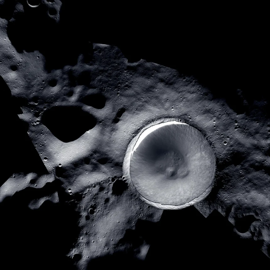
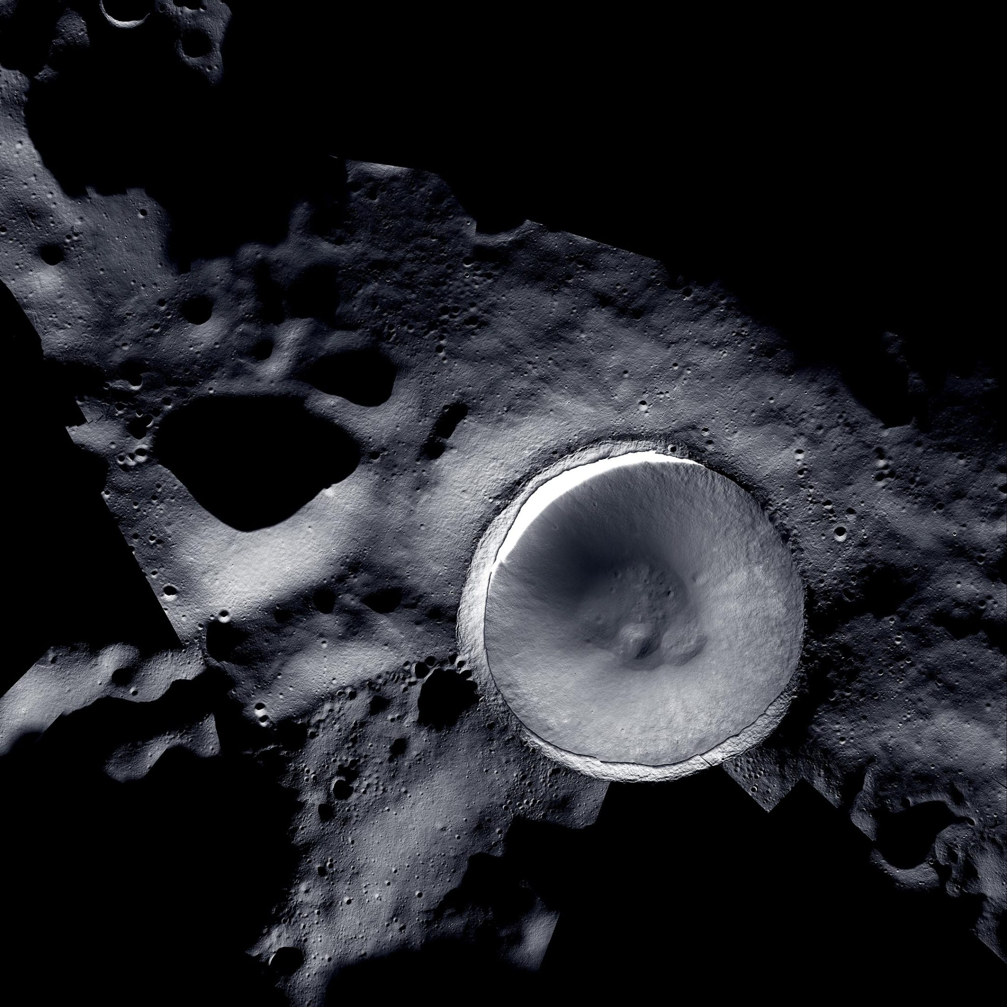
New mosaic at Shackleton Crater.Credit: Mosaic created by LROC (Lunar Reconnaissance Orbiter) and ShadowCam teams using images provided by NASA/KARI/ASU
LROC and ShadowCam are working together to unveil the Shackleton Crater mosaic, providing unparalleled insight into the Moon’s south pole and its potential ice sheet, and supporting future lunar exploration missions.
A new mosaic of Shackleton Crater shows the powerful synergy of two lunar-orbiting cameras working together to reveal unprecedented details of the moon’s south polar region.
This mosaic was created using images obtained by. LROC (Lunar Reconnaissance Orbiter Camera)from ShadowCam, which has been in operation since 2009. NASA An instrument mounted on KARI’s (Korea Aerospace Research Institute) spacecraft called Danuri. launched ShadowCam was developed by Malin Space Science Systems and Arizona State University.

NASA’s Lunar Reconnaissance Orbiter has been studying the Moon since June 2009. Credit: NASA
Complementary features of LROC and ShadowCam
Although LROC can capture detailed images of the lunar surface, it is limited in its ability to capture shadow areas of the moon that are not exposed to direct sunlight, known as permanent shadow regions. ShadowCam is 200 times more light sensitive than LROC and can operate successfully in these extremely dark conditions. reveal the characteristics Terrain details not visible in LROC. ShadowCam uses the moon’s geology and sunlight reflected from the Earth to take images of shadows.
However, ShadowCam’s light sensitivity prevents it from capturing images of directly illuminated parts of the moon, resulting in saturated results. Because each camera is optimized for the specific lighting conditions found near the moon’s poles, analysts can combine images from both instruments to capture the topography of both the brightest and darkest parts of the moon. and create comprehensive visual maps of geological features. Permanently shadowed areas within this mosaic, such as the internal floor and walls of Shackleton Crater, appear in great detail thanks to images from ShadowCam. In contrast, sunlit areas in this mosaic, such as the crater rim and sides, are the product of images collected by LROC.

Artist illustration of ShadowCam mapping Shackleton Crater. Credit: NASA
Scientific and exploration implications
Using ShadowCam, NASA is now able to image permanently shadowed areas of the Moon in greater detail than before, giving scientists a better view of the Moon’s south pole region. This area has never been explored by humans and is of great interest for science and exploration as it is thought to contain ice deposits and other frozen volatile materials. Scientists believe that layers of ice deposits have been present on the moon for millions or billions of years, and being able to study the samples could improve our understanding of how the moon and solar system evolved. There is a possibility that it will deepen. Ice deposits could also serve as important resources for exploration, as they are composed of hydrogen and oxygen, which can be used for rocket fuel and life support systems.
A more complete map of the Moon’s south polar region will be valuable for future surface exploration efforts, such as the VIPER (Volatile Polar Rover) and Artemis missions, to return humans to the lunar surface and to support long-term lunar missions. Establish a strong presence. Month.
About LROC
The Lunar Reconnaissance Orbiter Camera (LROC) is a camera system aboard NASA’s Lunar Reconnaissance Orbiter (LRO) spacecraft. Launched in 2009, LROC is designed to take high-resolution images of the lunar surface. Its main purpose is to help identify safe landing sites, identify potential resources, study the lunar environment and demonstrate new technologies. Detailed images from LROC have provided valuable insight into the Moon’s topography, geology, and supported a variety of scientific and exploration missions.
About shadow camera
ShadowCam is a highly light-sensitive camera instrument aboard KARI’s (Korea Aerospace Research Institute) spacecraft Danuri. Developed by Marine Space Science Systems and Arizona State University for his NASA, it is specifically designed to take images of permanently shadowed areas of the moon, areas that are never exposed to direct sunlight. I did. ShadowCam has the ability to operate successfully in extreme low-light conditions and uses the Moon’s geology and reflected sunlight from Earth to reveal terrain and terrain details that cannot be seen with other instruments such as LROC. Take a photo. Launched in August 2022, it will complement other lunar imaging systems by revealing details of the moon’s darkest regions.